
There are 8 wards in West Nipissing.
Each ward is represented by one Councillor.
On September 16, 2025, West Nipissing Municipal Council adopted By-law 2025-73 to redraw the municipal ward boundaries. As a result, some electors may now be assigned to a different ward for municipal elections.
Residents are encouraged to use the “Find My Ward” button above to determine which ward they are in. Learn more about each ward and its elected member of Council below.
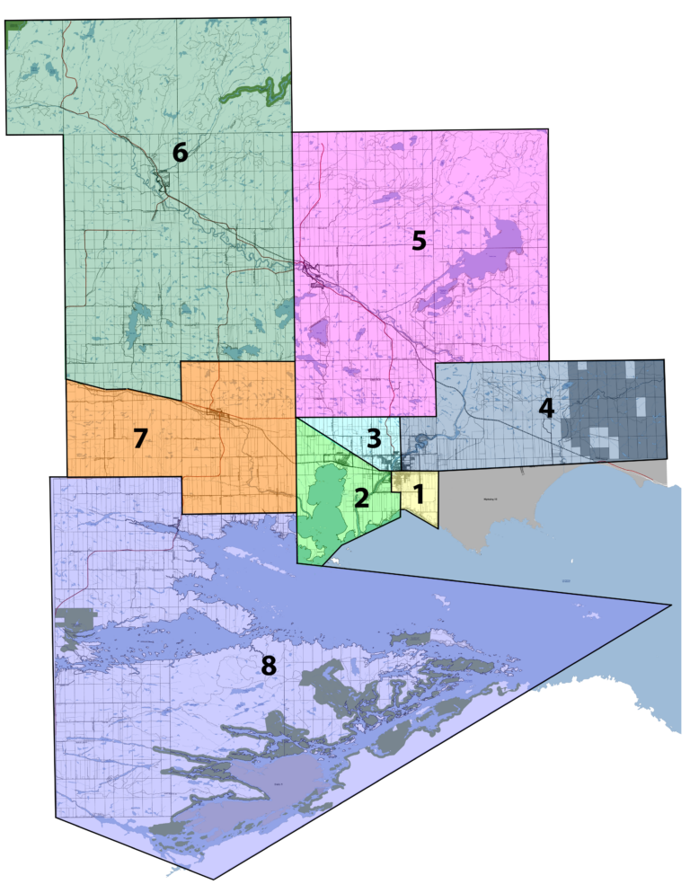
Ward Boundaries
Ward 1
Sturgeon Falls
Councillor: Kris Rivard
Ward 1 includes the area bounded by the east boundary of Springer Township, Highway 17, the shoreline of Lake Nipissing, Nipissing Street, Quesnel Road, Roy Street, and the Sturgeon River.
Ward 2
Sturgeon Falls and Cache Bay
Councillor: Roch St-Louis
Ward 2 includes the area bounded by Highway 17, Gauthier Road, the western boundary of Springer Township, the shoreline of Lake Nipissing, Nipissing Street, Quesnel Road, Roy Street, and the Sturgeon River.
Ward 3
Sturgeon Falls
Councillor: Daniel Gagné
Ward 3 includes the area bounded by Gauthier Road, Highway 17, Nipissing Street, the Sturgeon River, and the northern boundary of Concession 3 in Springer Township.
Ward 4
Sturgeon Falls
Councillor: Jamie Restoule
Ward 4 includes the Townships of Pedley and Beaucage and the area bounded by Levert Drive, the Sturgeon River, Nipissing Street, Highway 17, and the eastern boundary of Springer Township.
Ward 5
Crystal Falls and Field
Councillor: Kaitlynn Nicol
Ward 5 includes the portion of Springer Township north of the boundary between Concessions 3 and 4, the Township of Field, and the Townships of Grant, Bastedo, and Fell.
Ward 6
River Valley, Kipling, Desaulniers
Councillor: Roland Larabie
Ward 6 includes the portion of Kirkpatrick Township north of Highway 17, the Townships of Hugel, Badgerow, Crerar, Gibbons, Dana, and McWilliams, and the eastern half of Janes Township.
Ward 7
Verner
Councillor: Fernand Pellerin
Ward 7 includes the portion of Caldwell Township north of the boundary between Concessions B and C, and the portion of Kirkpatrick Township south of Highway 17.
Ward 8
Lavigne and North Monetville
Councillor: Georges Pharand
Ward 8 includes the portion of Caldwell Township south of the boundary between Concessions B and C, and the Townships of MacPherson, Loudon, Falconer, Latchford, and Bertram.
The ward maps are not fully accessible to screen readers. If you require assistance with the maps listed on this page, please contact us.